


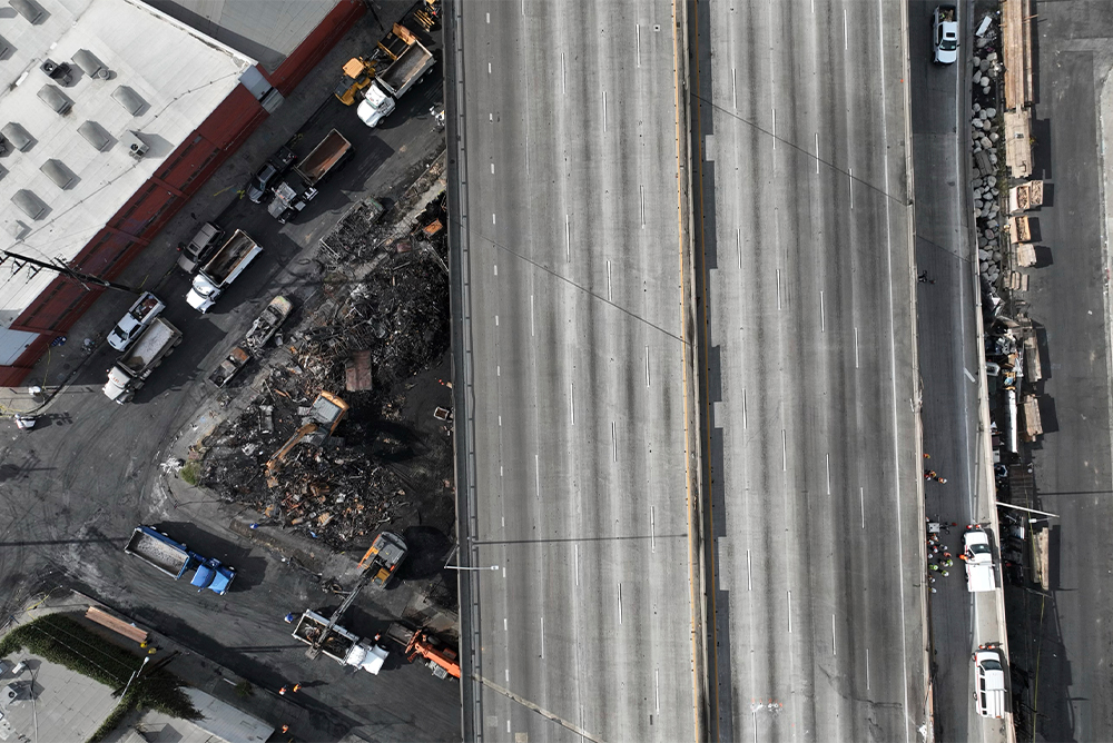
In many ways, Interstate 10 and federal highways like it exemplify national cohesion in the U.S. But the 10 also reinforced preexisting fissures and inequities in American society, writes Ten Across founder Wellington Reiter. Courtesy of AP Newsroom.
Funny thing about the world we have created and the structures we build—they are only really seen for what they are when in states of abandonment. Our built environment reveals our ambition, labor, materiality, and sometimes the folly of believing that our constructions, even massive assemblies of concrete and steel, will persist in perpetuity. As consumed as we are by daily obligations, we devote little time to consider the spaces we occupy and what they represent.
The recent week-long shutdown of Interstate 10 in downtown Los Angeles, after a huge fire underneath the freeway, left a sudden void in the heart of the nation’s second-largest city. Without the dizzying flow of commerce or the monotony of a daily commuting ritual, we found an unusual moment to witness the 10 for what it really is: a monument to our priorities including personal mobility, on-demand goods and services, and the expectation of government to keep everything flowing seamlessly. The lifestyle we take for granted was suddenly called into question by the absence of one roadway.
For some, the closure was a useful reminder of the need to rethink our relationship with the automobile and the air-polluting fossil fuels that most vehicles still burn. Others, such as the L.A. Times editorial board, seized the chance to reimagine transportation infrastructure and address the disastrous consequences large highway projects wrought as they were threaded through preexisting—and most often majority non-white—neighborhoods.
While we are at it, maybe this is an opportune time to consider reinvention of the city itself, as we leave behind 20th-century engineering and technology in favor of innovations we anticipate will foster more sustainable, equitable, and accessible urban environments.
This may seem like an inflated agenda to spin out from a single, isolated event. But we know in our collective gut that course corrections are necessary in many aspects of contemporary life and in the structures required to support it. Our infrastructure is a declarative statement of intent, reflecting who we are and the investments we are prepared to make to achieve various ends, for better and for worse. Given an opportunity for close observation—as the recent closure allowed—Interstate 10 can tell us much about ourselves and what we value.
Dan Walters of CalMatters wrote during the 10’s closure: “If any freeway is a cultural icon, it is Interstate 10, which stretches more than 2,460 miles through eight southern tier states, from the Pacific Ocean in Santa Monica to the Atlantic in Jacksonville, Florida.”
Most drivers may see the 10 not as an icon but as a mundane, utilitarian artifact, if they think much about it at all. But what Walters recognizes is that this transcontinental freeway is more than a road. Over the course of several thousand miles and wildly varying landscapes, Interstate 10 unites a dynamic, rapidly expanding, and diversifying area of the country.
The region I-10 spans is frequently referred to as the “Sun Belt,” a 20th-century reference to economies centered on recreation and retirement that the 10 itself helped to make possible.
But the southern tier of the U.S. is no longer characterized by leisure. It has become a place of rapid growth and industry. In many ways, this is the “new America”.
Today, the impacts of climate change are impossible to ignore in this area of the country. If we are to resolve the challenges of diminishing water supplies, drought, and fire, the western I-10 provides the laboratory. If there is to be a transition away from fossil fuels, it will be centered in the 10 corridor, with Houston as the energy capital of the world. If the global challenges of sea level rise, land loss, and increasingly extreme weather are to be addressed, the path of the 10 along the Gulf Coast is the proving ground. An I-10 road trip has become the essential tour through a future with which we have yet to come to terms.
As a product of the 1956 National Interstate and Defense Highways Act, Interstate 10 is an exemplar of national cohesion in the United States. The legislation for the creation of this national network of highways passed in the House of Representatives by a vote of 388 to 19, a level of functional bipartisanship that we can only marvel at today. This was America at its post-war apex, building a comprehensive, well-engineered transport system that would lift the nation to unprecedented levels of productivity and connection.
Yet even as it represented newfound capacity to build, the 10, like other interstate freeways, was used to reinforce preexisting fissures and inequities in American society. The planning choices by many cities benefited some neighborhoods and did lasting damage to others—as evident in the ways the 10 was forced through Boyle Heights in Los Angeles, the Fifth Ward in Houston, and Claiborne Avenue in New Orleans.
Some 60 years after the interstate program began, the Biden Administration is addressing the negative byproducts of the system through the new Reconnecting Communities and Neighborhoods (RCN) Program and buttressed by the Justice40 overlay, which directs 40 percent of certain federal investments to communities marginalized, underserved, and overburdened by pollution—ills in which highways are often the primary culprit. Whether impacted by climate change or man-made structures, community vitality and resiliency will be measured by the security of the most vulnerable populations.
From its origins in the 1956 federal mandate to current efforts to right past wrongs, the 10 has always had a political dimension. Today, this roadway connects the three most populous states—California, Texas, and Florida—each with an economy larger than most countries. Given their scale, these states have an outsized influence on the national dialogue, social issues, environmental policy, and even the textbooks students across the nation will read. Most importantly, they present vastly different templates for the future of the country…and maybe even for democracy itself.
The political dialogue moving back and forth along the 10 ay be even more consequential than the goods being transported between Los Angeles and Jacksonville . We need a common understanding of the government’s role to not only maintain our roads but to address the existential threats posed by a rapidly transforming environment. Rather than defining ourselves by difference, we need to see ourselves as “neighbors on the same street,” finding throughlines in shared issues, imagining infrastructure in more expansive terms, and building a new pathway to a more resilient future.
The U.S. Interstate 10 corridor is positioned on the front lines of demographic, social, economic, and climate change, and presents the challenges of the 21st century in their highest relief. The case can be made for this “iconic” transect as the leading indicator for the nation as a whole and our capacity to respond to a knowable future. This is the inspiration for the Ten Across initiative
Ten Across is about equipping subsequent generations with the tools to manage a world in flux, one that is unfortunately going to be warmer, dryer, and more unsettled. This is being achieved through education, strategic communications, and forums for engaging the critical issues of our time, many of which are represented in their extremes along the 10.
Send A Letter To the Editors